


Descripción de Természetjáró, a túratervező
The online tourist guide of Hungary, specially developed for hikers, bikers and water sports lovers, featuring a built-in tour planner, as well as hundreds of recommended tours and thousands of POIs, all with detailed descriptions and plenty of photographs, comfortably viewable on an interactive map.
Features
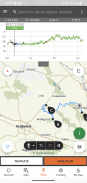
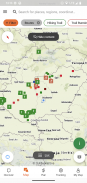
• Interactive, zoomable map with all the marked trails, showing your current position
• A convenient way to plan your own tour on the map, and get length, duration and elevation profile immediately
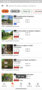
• Hundreds of recommended tours for hikers, bikers and canoers, with practical data, detailed description of the best sights nearby, natural and cultural background, good quality photographs and information on how to get there
• The complete Hungarian Blue Tour, with official sections and route, POIs and accomodations
• Offline map download
• On-the-fly navigation along the route, optionally with voice instructions
• Record your route
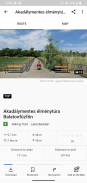
• Thousands of recommended sights, including lookout towers, natural panorama points, forest trains, fortresses and museums, with detailed description, good quality photographs, plus information on how to get there
• Hundreds of accomodations, including huts, tourist hotels and apartments, near marked trails
• List of places accepting TEKA (a special tourist card that provides discount for hikers in museums, accomodations, on the train etc.)
• Synchronise all your content between computer and mobile devices running the app
• Create your own lists of your favourite tours and POIs
• Check the weather forecast
• Useful tools built in, such as peak finder, compass, inclinometer and QR-code reader
• Emergency phone call function right from the app, with your current position provided
• List every content by distance from you
• Community services: rate and share contents with your friends
Please note that our contents are changed and upgraded on a daily basis.
Attention: Continued use of GPS running in the background can dramatically decrease battery life.
Our desktop version:
https://www.termeszetjaro.hu/hu/
Follow us on Facebook:
https://www.facebook.com/Termeszetjaro.hu/
Contact us:
info@termeszetjaro.hu
More about the TEKA card:
http://www.termeszetjarokartya.hu/
La guía turística en línea de Hungría, especialmente desarrollada para excursionistas, ciclistas y amantes de los deportes acuáticos, con un planificador integrado, así como cientos de visitas recomendadas y miles de puntos de interés, todos con descripciones detalladas y muchas fotografías, cómodamente visibles en un mapa interactivo.
Funciones
• Interactivo, mapa con zoom con todos los senderos marcados, mostrando su posición actual
• Una forma conveniente de planificar su propio recorrido en el mapa, y obtener la duración, la duración y el perfil de elevación de inmediato
• Cientos de tours recomendados para excursionistas, ciclistas y canoeros, con datos prácticos, descripción detallada de los mejores lugares de interés cercanos, entorno natural y cultural, fotografías de buena calidad e información sobre cómo llegar
• El recorrido azul húngaro completo , con secciones y rutas oficiales, puntos de interés y alojamientos
• Descarga de mapa sin conexión
• Navegación sobre la marcha a lo largo de la ruta, opcionalmente con instrucciones de voz
• Grabe su ruta
• Miles de vistas recomendadas , incluidas torres de observación, puntos panorámicos naturales, trenes forestales, fortalezas y museos, con una descripción detallada, fotografías de buena calidad, además de información sobre cómo llegar
• Cientos de alojamientos , incluidas cabañas, hoteles y apartamentos turísticos, senderos cercanos
• Lista de lugares que aceptan TEKA (una tarjeta turística especial que ofrece descuentos para excursionistas en museos, alojamientos, en el tren, etc.)
• Sincronice todo su contenido entre la computadora y los dispositivos móviles que ejecutan la aplicación
• Crea tus propias listas de tus recorridos y puntos de interés favoritos
• Verifique el pronóstico del clima
• Herramientas útiles integradas, como buscador de picos, brújula, inclinómetro y lector de código QR
• Función Llamada de emergencia directamente desde la aplicación, con su posición actual provista
• Haga una lista de cada contenido por distancia de usted
• Servicios comunitarios: calificar y compartir contenidos con tus amigos
Tenga en cuenta que nuestros contenidos se cambian y actualizan a diario.
Atención: El uso continuo del GPS en segundo plano puede reducir drásticamente la duración de la batería.
Nuestra versión de escritorio:
https://www.termeszetjaro.hu/hu/
Síganos en Facebook:
https://www.facebook.com/Termeszetjaro.hu/
Contáctenos:
info@termeszetjaro.hu
Más sobre la tarjeta TEKA:
http://www.termeszetjarokartya.hu/
The online tourist guide of Hungary, specially developed for hikers, bikers and water sports lovers, featuring a built-in tour planner, as well as hundreds of recommended tours and thousands of POIs, all with detailed descriptions and plenty of photographs, comfortably viewable on an interactive map.
Features
• Interactive, zoomable map with all the marked trails, showing your current position
• A convenient way to plan your own tour on the map, and get length, duration and elevation profile immediately
• Hundreds of recommended tours for hikers, bikers and canoers, with practical data, detailed description of the best sights nearby, natural and cultural background, good quality photographs and information on how to get there
• The complete Hungarian Blue Tour, with official sections and route, POIs and accomodations
• Offline map download
• On-the-fly navigation along the route, optionally with voice instructions
• Record your route
• Thousands of recommended sights, including lookout towers, natural panorama points, forest trains, fortresses and museums, with detailed description, good quality photographs, plus information on how to get there
• Hundreds of accomodations, including huts, tourist hotels and apartments, near marked trails
• List of places accepting TEKA (a special tourist card that provides discount for hikers in museums, accomodations, on the train etc.)
• Synchronise all your content between computer and mobile devices running the app
• Create your own lists of your favourite tours and POIs
• Check the weather forecast
• Useful tools built in, such as peak finder, compass, inclinometer and QR-code reader
• Emergency phone call function right from the app, with your current position provided
• List every content by distance from you
• Community services: rate and share contents with your friends
Please note that our contents are changed and upgraded on a daily basis.
Attention: Continued use of GPS running in the background can dramatically decrease battery life.
Our desktop version:
https://www.termeszetjaro.hu/hu/
Follow us on Facebook:
https://www.facebook.com/Termeszetjaro.hu/
Contact us:
info@termeszetjaro.hu
More about the TEKA card:
http://www.termeszetjarokartya.hu/
Természetjáró, a túratervező - Información de APK
Version de la app: 3.14.9Paquete: com.outdooractive.mtszApps en la misma categoría
Quizá también te interese...


